Showing posts with label open space. Show all posts

Thursday, June 19, 2008

Walk for Open Space Saturday

The Allston Brighton Green Space Advocates and the Allston Brighton Community Development Corporation are hosting a "Walk for Open Space" this Saturday, June 21st at 10 am next to the Veronica Smith Senior Center.

While the walk is a fund-raising event for the ABGSA, there is no requirement to collect donations in order to participate.

There are many little "pocket" parks and urban wilds scattered across Allston-Brighton. Visiting all of them in a single walk would amount to a death march, so it is fortunate that the ABGSA has trimmed the route down to a manageable four miles. Charlie might, however, still choose to do the scenic route.

Monday, February 25, 2008

Allston-Brighton Green Gathering Tuesday Night


The Allston Brighton Green Space Advocates, a group sponsored by the Allston Brighton Community Development Corporation, is hosting their annual "Green Gathering" on Tuesday night for neighborhood groups devoted to green spaces and other interested area residents. The event is open to the public.

This is a slightly crunchy affair that provides an oversight into ongoing activities related to open spaces in Allston-Brighton: the green streets initiative; work on obtaining conservation easements; connections with the city's 100,000 tree initiative; and networking with other neighborhood groups working on open space issues. Neighborhood groups are encouraged to bring literature along about their group for tabling at the event.

Allston-Brighton has only 4.8 acres of open space per 1000 residents, well below the
city-wide average of 7.9 acres. Due to the presence of large institutions in A-B, a large fraction
of that open space is owned privately. For example, according to the Boston Parks and Recreation department, 58% of the neighborhood's private, unprotected open space is contained within the St. John's Seminary land purchased by Boston College.

Tuesday, February 26, 2008
6:00 - 8:30 pm [probably 6:00 pm for dinner; formal presentation at 6:30 or 7:00 pm]
EF International Language School
200 Lake Street, Brighton, MA 02135
Dinner and dessert provided!

For more information, contact:
Ava Chan, ABCDC, email, phone: 617-787-3874

Tuesday, January 29, 2008

BC Task Force Meeting Today at 6:30 pm: Open Space and Academic/Administrative Buildings

BC Task Force Meeting
Tuesday, January 22, 2008, 6:30-8:30 pm
Brighton Marine Health Center, 77 Warren Street, 3rd floor, Brighton MA 02135

For more information, contact: John Fitzgerald, Project Manager, BRA, 617-918-4267

Public comments on the IMPNF: Due February 5, 2008 to the BRA

Note: The BC Task Force has requested that attendees, if possible, provide them with written comments at their meetings. It doesn't have to be a formally-written letter, etc., but anything to help them assemble information in addition to verbal comments at the meetings. Address letters to Jean Woods, Chair, BC Task Force.

Agenda: The following elements of BC's 10-year institutional master plan
  • Open Space
  • Academic Buildings and Usage
  • Administrative Buildings and Usage
  • Summary
BC's master plan website with electronic version of their project notification form. Current summary of their campus is in Chapter 2; proposed new projects in the 10-year IMP are in Chapter 3; sustainability issues are in Chapter 8.

Open Space. In 2004-7, Boston College acquired approximately 65 acres of land (the former St. John's Seminary land, now referred to by BC as their "Brighton Campus") from the Archdiocese of Boston. This land has been previously inventoried by the Boston Parks and Recreation Department as part of the privately-owned open space in Allston-Brighton (see, for example, the previous master plan by the department). The Brighton Campus comprises more than 10% of all the open space in Allston-Brighton.

The Brighton Campus has an underlying zoning of Conservation Protection Subdistrict under Article 51 of the city's zoning code. (Article 51 defines the zoning for Allston-Brighton.) BC's Institutional Master Plan Amendment of 2006 put an institutional master plan overlay onto portions of the Brighton Campus. Their IMPA of October 2007, which is still undergoing Article 80 review by the Boston Redevelopment Authority, might seek to extend the IMP overlay to the entire site; alternatively, the IMPNF of December 2007 might do the same. (Article 80 defines the review and re-zoning process for large developments and institutional master plans.)

While the Article 80 IMP review allows re-zoning of the site, the underlying zoning is not ignored in the process. As Gerald Autler, Senior Project Manager of the BRA, wrote in April 2007:
"We certainly take aspects of the underlying zoning into account during the IMP process -- for example, the goals of the Conservation Protection Subdistrict would not be forgotten, even if the zoning provisions of the CPS do not literally apply."
According to Article 51, development in a CPS-zoned property should cluster buildings at the interior of the site an avoid impacting natural features of the property. As in any zoning, there are a series of permitted, conditionally-allowed, and forbidden uses for a CPS-zoned property under Article 51.
  • Allowed uses under Article 51 include: museum; open space; "group residence, limited", single- and multi-family houses, or townhouses; "accessory parking" (connected to another lawful use); "accessory cafeteria"; and "accessory dormitory".
  • Conditionally-allowed uses include: art gallery; auditorium, concert hall, or theater; conference center or bed-and-breakast; office space (except for retail); grounds for sports; open space recreational building; "outdoor place of recreation for profit"; research laboratory; and lodging house.
  • Forbidden uses include: stadium; "dormitory not accessory to a use"; hotel, motel, or "executive suites"; restaurants and other retail uses; outdoor storage of junk, scrap, fuel, minerals, etc.; trade shops (carpenter, electrician, machine, etc.); and parking garage or lot (unless an ancillary use connected to another lawful use).

Conservation Restriction. A conservation restriction is a legally-binding document, operating outside of the zoning process, that can preserve open space in perpetuity. A public agency is typically charged with monitoring compliance, and the restriction can only be overturned by a 2/3 vote of the State Legislature.

A number of private developers have seen these conservation restrictions as good for both themselves and the surrounding community. The EF International School, for example, has worked with the Brighton community to development a pair of conservation restrictions on their Lake Street property to preserve open space in exchange for an expansion of their facilities. Harvard University has also entered into an 875-year conservation restriction on a parcel connected to the Arnold Arboretum, in exchange for a proposed development project.

Boston College has not included a conservation restriction in their IMPNF or presentations to the community.

A number of Brighton residents have proposed particular sites for conservation restrictions that could be part of the Article 80 community benefits related to BC's IMP:
  • Wooded hillside along Lake Street;
  • Athletic fields on the Brighton Campus; and
  • Orchard near the southeast corner of the Brighton Campus (i.e., bordering Greycliff Road).
The Boston Globe's editorial board has already weighed in on this issue:
BC’s president, the Rev. William Leahy, points to a buffer zone of trees between the two proposed dorms and homes on Lake Street. But he is unwilling to pledge that the buffer zone will remain a permanent fixture. Such a stiff-necked approach is likely to invite the same inflexible attitude on the part of neighbors.
Preserving Natural Features. Many aspects of the Brighton Campus proposed development follow these CPS guidelines in clustering the buildings in interior locations and avoiding (or preserving) natural features of the land: the athletic facilities use existing flat field space; the parking garage avoids the steep, hillside meadow nearby; all the development avoids the wooded hillside along Lake Street; and the Foster Street development does not modify the Foster Rock or the ledge near Portina Road houses.

Other aspects of the development do not appear to preserve features (or at least require clarification): the undergraduate dormitory site on or near a rock outcropping along Commonwealth Avenue; and the removal of a substantial length of the stone wall on both sides of Commonwealth Avenue.

Academic and Administrative Buildings and Uses.
Three new buildings (possibly connected together as only one or two buildings) are proposed along the Brighton Campus's southern edge on Commonwealth Avenue as part of this 10-year IMP:
  • Department of Fine Arts, 4-5 stories, 60-70 feet tall, 30,000 square feet;
  • Art Museum, 3-story, probably also 60-70 feet tall (e.g., compare with Harvard's proposed HUAM at Barry's Corner, which is also very tall even though only three stories), 21,000 square feet; and
  • Auditorium, 1200 seats, 25,000 square feet.
Uses for the auditorium are unclear in the IMPNF; possibilities could include academic conferences and seminars, musical concerts, rock concerts, theater plays, etc. On-site parking related to some of these uses might be an issue to be raised.

Renovations are also planned for number of buildings on the Brighton Campus purchased from the Archdiocese. The Chancery, Creagh Library, and part of St. John's Hall (?) are listed as being converted to administrative use, while Bishop Peterson Hall would be converted to administrative and academic use. Note that Bishop Peterson Hall's renovation and subsequent use is currently in question: the IMPNF states that the IMPA's proposed use is infeasible for office and academic uses of the School of Theology and Ministry, such that St. William's Hall will be used for the STM instead.

Those many administrative office buildings in the Brighton Campus may house a potentially large number of employees who would presumably move from their current offices elsewhere at BC. No indication is given in the IMPNF as to which offices would be moving, or what the employees' previous offices would be used for after they are vacated.

The 10-year IMP for BC's campus in Newton contains many academic projects. On the main Chestnut Hill Campus, five projects are proposed:
  • Academic building for the Humanities;
  • Academic building for Graduate School of Social Work and Connell School of Nursing;
  • Stokes Commons, a student center and dining facility;
  • New Science Center (first phase) replacing Cushing Hall; and
  • Renovation of Carney Hall (academic and administrative).
Two academic and administrative projects are proposed for the Newton Campus (i.e., Law School site):
  • Replacement of Smith Wing; and
  • Renovation of Stuart Hall.

Monday, December 03, 2007

Boston Parks Open Space Plan Open for Comments Until 12/9

The Boston Parks and Recreation Department has published their draft open space plan for 2008-2012.  Current work in 2007 is in some kind of purgatory between the previous 2002-2006 plan and the proposed next one.

I must say that I heard nothing about the fact that they had actually published a draft plan until I read yesterday's short article in the Boston Globe's City Weekly section.  Failure to get the word out would explain why Mary Hines, spokeswoman for Mayor Thomas Menino, said that the city has received few public comments to date.

The department wants feedback on their plan, which you can submit until December 9th (this Sunday) using the online form.

One member of the Friends of Rogers Park has already noted some interesting details:
"Rogers Park is the sixteenth most often used park in the city of Boston, second most used in Allston-Brighton and received the lowest funding from capital projects spending from 2001-2006, considerably lower than any other park in Allston-Brighton."
The Parks Department's open space is the place to address such disparities so that significant capital expenditures can be targeted where they are most needed.

Friday, July 06, 2007

Harvard Agrees to Deed Restriction on Arnold Arboretum Project

Harvard University, owner of the Arnold Arboretum, is proposing a 875-year deed restriction on a 14.2 acre parcel adjacent to the Arboretum property in exchange for approval of their plan to build a 45,000 square foot research facility. These kinds of deed restrictions protect property against future development, and can only be over-ridden by a 2/3 vote of the State Legislature. Harvard's agreement will allow them to build only 185,000 square feet of buildings over the next 875 years, according to today's Boston Globe.

There are some questions, however, about whether or not the institution -- or the City of Boston -- obey the deed restrictions. As I previously posted, the Longfellow Area Neighborhood Association claims that the City violated 1973 deed restriction on Joyce Kilmer Park on Centre Street by allowing an expansion of the Rehab Center and paving of parkland for parking. Parkland vs. parking -- aren't those almost the same words?

A similar deed restriction was recently agreed to right here in Brighton: the EF International School agreed to an open space deed restriction on the bulk of their property, known as The Cenacle, in exchange for a modest expansion of their facilities (to include a business school) at 200 Lake Street, Brighton.
"The reason we are offering an easement to the community," said Lori van Dam, executive vice president of Information and Communication at EF, "is that we also have a significant stake in seeing the property preserved. We feel strongly that it is an important natural resource, and it is a large part of what our students, teachers, and administrators enjoy about the location."
The Cenacle agreement is a model that many people in the neighborhood would like to emulate, particularly as a means to protect portions of the former St. John's Seminary grounds from future development by Boston College. The seminary grounds comprise more than 10% of all of Allston-Brighton's unprotected open space.

Now that Harvard has shown that an old institution with big expansion plans of its own has nothing to fear from agreeing to a deed restriction, we'll be watching Boston College's next moves. Do they agree that they "have a significant stake" in seeing the former seminary land (Brighton Campus) property preserved? Do they recognize it as "an important natural resource" that its own students and employees might "enjoy about the location"?

Harvard clearly sees an open space deed restriction as a win-win for both the community and the institution. Will Boston College see it the same way, too?

Friday, June 15, 2007

St. Elizabeth's Starting Site Preparation for New Emergency Room

No sickening smack yet, but it's probably just around the corner: St. Elizabeth's Medical Center has conducted their formal, photo-op ground-breaking for the site of their new Emergency Room. No excavation yet while they still do site preparation. Fences have been seen blocking off access to the hillside site.

Few in the neighborhood doubted the need for St. Elizabeth's to update their aging ER facility.

The project's associated loss of open space (and trees), however, didn't please everyone:
“I realize that the hillside will disappear and I accept that,” [said Charlie Vasiliades], “but I don’t feel that St. E’s offered enough in return to compensate for the loss of that green space.”

Vasiliades wanted the hospital to grant a permanent easement on the land behind the campus abutting the future new access road, in order to prevent any future development there.
Thneeds 1, Brown Bar-ba-loots 0.

Monday, May 07, 2007

A Sickening Smack: St. Elizabeth's Medical Center Tree Chopping Project

The day is fast arriving when St. Elizabeth's Medical Center will chop down more than a dozen trees on their property to make way for a (temporary) access road.


There have been orange stakes with red flags the last few weeks scattered throughout both the site of the new emergency room and the new access road.

The access road land has been classified under Article 51 of the zoning code as a Conservation Protection Subdistrict overlay (as well as another overlay of the institutional master plan area); obviously, conservation holds little sway when the institution rammed this road through the Article 80 institutional master plan process.

Such a lovely sight for the moment:

And at that very moment, we heard a loud whack!
From outside in the fields came a sickening smack
of an axe on a tree. Then we heard the tree fall.

BUT...
business is business!
And business must grow
regardless of crummies in tummies, you know.
I hope we can someday bring back the Brown Bar-ba-loots, Swomee Swans, and Humming-Fish.

(The Lorax, Copyright 1971 by Dr. Seuss Enterprises, L.P.)

Thursday, May 03, 2007

Arnold Arboretum: City Failed on Its Promise to Protect Open Space

Harvard Magazine recently ran an article giving some food-for-thought in dealing with institutional expansion and the City of Boston's failure to deliver on promises to protect open spaces.

The article quotes from the Longfellow Area Neighborhood Association:
“Forty years ago, the City gave the Hebrew Rehabilitation Center permission to build a facility for seniors at the nine-acre Joyce Kilmer Park on Centre Street….After promising to protect the remaining open space at that site, the City later allowed the Rehab Center to double in size in 1973. Most of the remaining parkland was subsequently paved for cars in violation of public deed restrictions on the property.…The lesson of Joyce Kilmer Park is that once an institution gets established in a location, there is little a neighborhood can do to limit its eventual expansion.”
Quite sobering.

Wednesday, April 25, 2007

Turkey Trot

While running on Kenrick Street this morning, just over the Newton line, I again ran across three of our local, wild turkeys. One male was displaying alongside two females. Photo of male displaying not mine (nor from Brighton):


The street location is near to the Newton Commonwealth Golf Course (who ought to modify their logo), further down the street from Chandler Pond, the Cenacle, Rogers Park, and St. John's Seminary open spaces. Charlie Vasiliades made the point on Saturday's walking tour that adjacent and/or connected sets of open spaces support the presence of wild animals like these turkeys. Here is a map of these Brighton open spaces from the Boston Parks Department master plan 2001-2006, where the turkey sighting is at the middle-left-edge of the map:

Monday, April 23, 2007

Pictures from the Walking Tour of BC's Brighton Campus: I. Athletic Facilities

The community-led walking tour of Boston College's Brighton Campus (former Archdiocese land) took place on Saturday, April 21. The tour was led by Charlie Vasiliades and Wilma Wetterstrom and focused on viewing the open space, inspecting the topological features, and discussing the history of the site. Questions arose about particular proposals in BC's master plan, which were fielded by Tom Keady and Jeanne Levesque of BC's Office of Governmental and Community Affairs. A total of 40-50 people attended at some point during the tour, including from the BC Task Force and elected officials.

Most attendees appeared struck by the great beauty of a few particular locations in the tour, especially the hill with the former Cardinal's tomb (slated for demolition), the view from the Cardinal's former residence and the adjacent meadow/orchard, and the forested sections bordering Lake Street. Immense quantities of broken glass all over the Foster Rock were disappointing, however.

Here are some images taken during the tour of the athletic fields site. Below each one is a satellite picture and BC's March 2007 master plan, both with the approximate vantage point of the image identified.

Baseball Stadium [front] and Support Building [rear]


Baseball stadium: 2000-seats, press box, lights (80-foot?), artificial turf, etc.
Support building: see below.

BC's artist's conception from similar orientation (but much more elevated), although note that the support building design, as well as the softball stadium location, have changed since this drawing was made:


Support Building


Coaches offices, workout rooms, batting cages, lockers, restrooms, concessions.
A little bit difficult to see due to the enclosed parking lots in the foreground.

Brighton Fields Parking Garage and Racquetball Courts [roof]


Note that the new building would be on the RHS and off-image to the right of my picture (and will be much bigger and taller than the existing building in the picture).

160-200 parking spaces on two levels. Enclosed racquetball (i.e., tennis) on top.

Multipurpose Field


Intramurals, etc.


BC Magazine ran a slideshow in 2004 which has photos of the Brighton Campus from various perspectives.

Historical 1875 Map of St. John's Seminary

At the community walking tour of the St. John's Seminary land on Saturday, April 21, guide Wilma Wetterstrom brought along copies of the 1875 map of the property. I've laid it side-by-side with a modern, satellite image of the property.


This and other historical maps of Allston-Brighton have been scanned in by the Brighton Allston Historical Society, and are available online. A great resource.

Wednesday, April 18, 2007

Walking Tour of Former Archdiocese Property: Saturday 4/21 at 11:00 am

Community Walking Tour of the Former Archdiocese Property

When: Saturday, April 21st , 11:00 am

Where: Meet at Clements Hall parking lot, 197 Foster Street, Brighton

The focus of the walking tour will be to view the open space, inspect the topographical features, and discuss the historical background of the site which contains the locations of several developments (new buildings and athletic stadiums) proposed by Boston College as part of its master planning process.

The tour will be led by long-time Brighton residents Charlie Vasiliades and Wilma Wetterstrom. One or more representatives from BC will also be on hand to answer questions.

The tour is expected to last 1½ hours. Comfortable walking shoes are advised. Rain or shine.

For more information, contact:
Mike Pahre, pahre@comcast.net, 617-216-1447; or
Charlie Vasiliades, 617-254-7024

PDF flyer can be found here.


Photos from the tour can be found here.

Wednesday, April 11, 2007

BC Neighbors Forum: Public Meeting Thursday, April 12 at 7:00pm

BC Neighbors Forum
Public Meeting

Thursday, April 12, 2007
7:00 pm

Brighton Marine Health Center
77 Warren Street, Brighton

See below for information (click for larger version). Also see the PDF attachment to the BC Neighbors Forum available from this posting.

Sunday, March 25, 2007

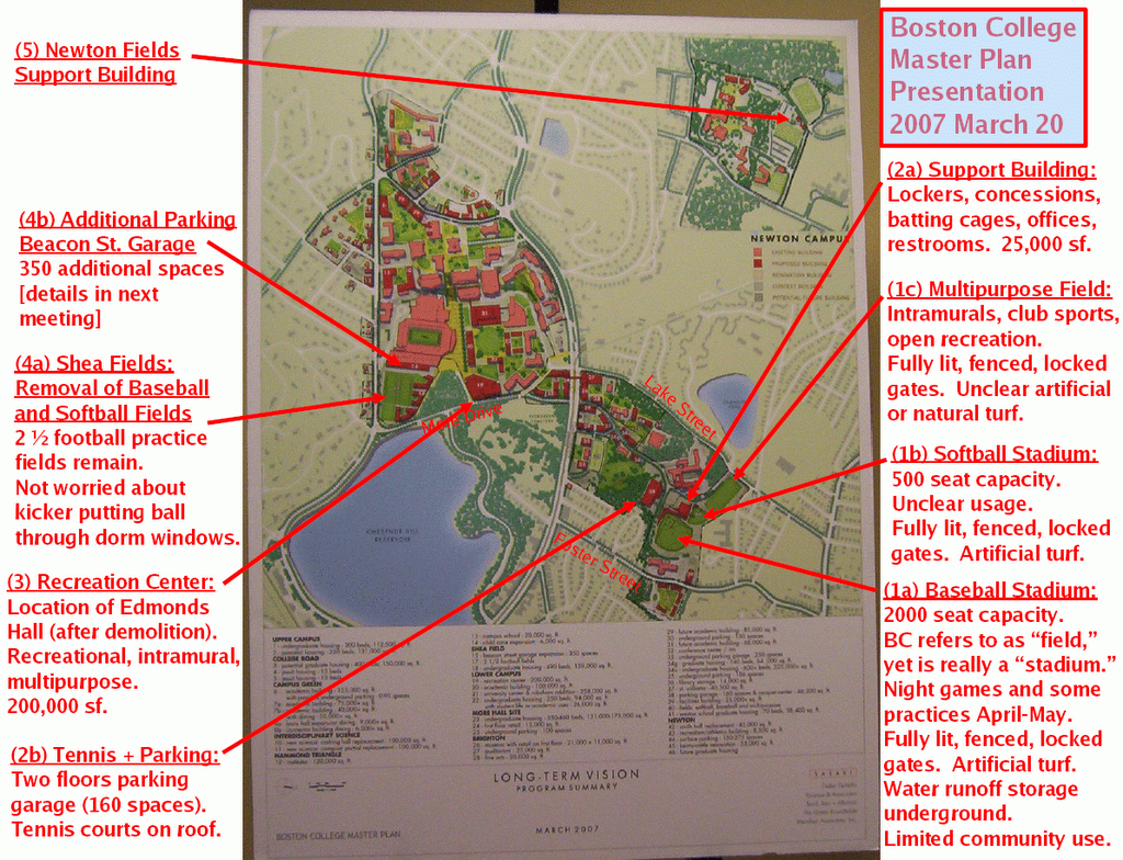
Boston College's Athletics Plans: Summary

At the Boston College Task Force meeting on Tuesday, March 20, 2007, Boston College planners and their partners at Sasaki Associates presented a housing plan for the next ten years of their development and expansion.

Below is my notated version of the visual that they displayed at the meeting:


A PDF version of the figure can be found attached to the post at the GoogleGroup BC_Neighbors_Forum.


SUMMARY OF ATHLETICS PRESENTATION

BC presented a series of five sets of construction related to
athletics: varsity, intramural, and informal recreation.

PDF attached.

The order of the projects appears to be roughly sequential, but may
not be strictly so. (#3 and #4a would seem an appropriate swap.)

I have kept BC's numbering scheme with the following modifications:
* split #1 into a, b, and c.
* split #2 into a and b.
* added #4b (parking addition next to Alumni Stadium [football].

(1)(a) Baseball Stadium: 2000 seat capacity, probably on benches.
Press box behind home plate. Put into natural features of site.
Approximately 50 feet elevation difference between field and
neighboring houses to south (according to statements made in February
20, 2007 meeting). Will be fully lit for night games and practices.
At previous meeting, expressed willingness to only hold 10-ish night
practices and 10-ish night games per year, but no such statement at
this meeting. Games occur April-May on Friday/Saturday nights and
Saturday/Sunday afternoons. Artificial turf (astroturf). Underground
tanks to be built to collect storm water in order to release slowly
back into water table. Will be fully fenced, gated, and locked off.
Limited community usage will be allowed -- only approved, organized
activities (no pick-up games). 2000 seat capacity would still be
lowest-capacity baseball stadium in ACC.

(1)(b) Softball Stadium: 500 seat capacity, probably on benches.
Will be fully lit for night games and practices. Unclear months for
games. Artificial turf (astroturf). Underground tanks (like baseball
stadium). Will be fully fenced, gated, and locked off. Unclear
community usage.

(1)(c) Multipurpose Field. Intramural sports, club sports, informal
recreation. Unsure if will be natural or artificial turf. If
artificial turf, then have underground tanks (like baseball stadium).
Will be fully fenced, gated, and locked off. Unclear community usage.

(2)(a) Support Building. Lockers, concessions, batting cages,
offices, restrooms. 25,000 square feet (sf).

(2)(b) Parking Garage and Tennis Courts. Built adjacent to hillside;
some discussion about how the hillside would be respected, but details
murky. Two levels of parking with 160 spaces. Tennis courts built
onto top of building.

(3) Recreation Center. After Edmonds Hall is demolished, will make
way for Recreation Center to be built on the site. Recreational
usage, multipurpose, primarily oriented to student use. 200,000 sf.

(4)(a) Shea Fields. Removal of baseball and softball fields from
site. Reconfiguration of remaining fields into 2 1/2 football
practice fields. Part of existing field space will have dorms built
onto it (see housing slide and discussion). Underground tanks to be
built to collect storm water in order to release slowly back into
water table. Unclear if natural or artificial surface.

(4)(b) Expansion of Beacon Street Parking Garage. Not discussed at
the meeting (presumably will be at next meeting on traffic, parking,
and transportation), but is part of the athletic support building
program nonetheless. 350 new parking spaces to be added.

(5) Newton Fields Support Building. Near to BC Law School in Newton.
8,500 sf.


Alternate visual

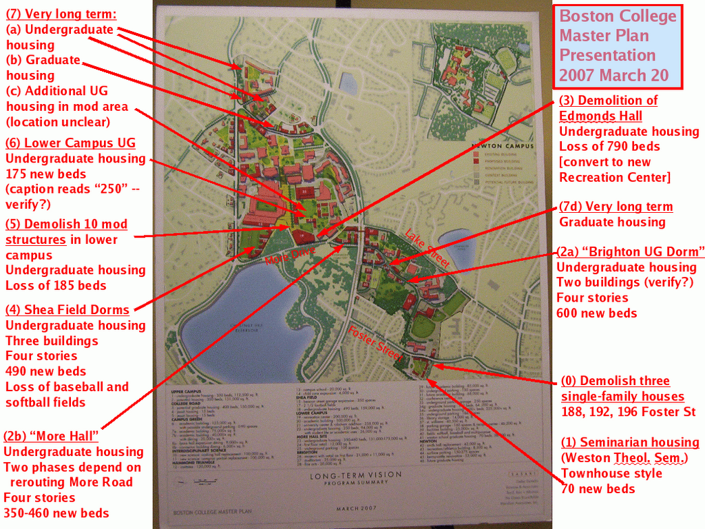
Boston College's Housing Plans: Summary

At the Boston College Task Force meeting on Tuesday, March 20, 2007, Boston College planners and their partners at Sasaki Associates presented a housing plan for the next ten years of their development and expansion.

Below is my notated version of the visual that they displayed at the meeting:


A PDF version of the figure can be found attached to the post at the GoogleGroup BC_Neighbors_Forum.

They expect to file an IMPNF with the BRA around mid-May 2007, although
a draft of it may be made available to the task force at an earlier date
(or maybe even to the community).


SUMMARY OF HOUSING PRESENTATION

BC presented a series of seven sets of construction and demolition
related to housing (graduate and undergraduate students, as well as
seminarian).

Notes:
#1 seems to be independent of the others.
#2-6 are sequential: build/construct #2, then do #3, then #4, etc.
#7 is very long-term, and uncertain.

I have added #0, since they neglected to note a necessary demolition
that must occur before #1. I have broken down #2 into 2a and 2b, and #7
into 7a, 7b, etc. Otherwise, the numbering scheme follows BC's scheme.

(0) Demolition of single-family houses at 188, 192, 196 Foster Street.

(1) Seminary Housing: Construction of Jesuit, non-family,
townhouse-style housing for Weston Theological Seminarians. Height
unclear. 70 new beds.

(2a) "Brighton UG Dorm" [my name]: Construction of undergraduate
housing in the middle of the Lake Street property purchased from the
Archdiocese. Access primarily through new inner, feeder road from Comm.
Ave. Housing in pods of four. For juniors and seniors. Some mention
of utilizing old gymnasium in connection with it. Four stories tall,
and partially up hillside (so will appear taller from future baseball
field). Believed to be two buildings, but cannot locate both on map.
600 new beds.

(2b) "More Hall": SE corner of Lake Street/More Road and Comm Ave
(i) Demolition of existing building (former law school)
(ii) Construction of undergraduate housing. Housing in pods of four.
Four stories tall. 350-460 total new beds:
phase 1: 350 new beds with More Road unchanged
phase 2: 110 additional beds if More Road re-routed
--> thus totalling 460 = 350 + 110

(3) Demolition of Edmonds Hall in the main, lower campus. Loss of 790
beds. [Later conversion to a new Recreation Center.]

(4) "Shea Field UG Dorms" [my name]: Construction of three buildings of
undergraduate housing on N and NE side of current Shea Fields. Removal
of baseball and softball fields; football practice fields remain. Four
stories high. 490 new beds.

(5) Demolition of 10 "Mod" structures in lower campus (which were
supposed to be only temporary housing decades ago, but were never
removed). Loss of 185 beds.

(6) "New Mods UG Dorm" [my name]: Construction of undergraduate housing
around where the mods currently exist. Four stories high. 175 new beds.

(7) Long-term planning -- very uncertain, so take with a grain of salt.
(7a) Undergraduate housing in upper campus: 300 + 350 beds.
(7b) Graduate student housing in upper campus: 400 beds
(7c) Undergraduate housing in lower campus (more mods): unclear from
map, but part of powerpoint presentation, so need verification
(7d) Graduate student housing in Lake Street property: 140 beds


UNDERGRADUATE BED SCORE CARD

-----------------------------------------------------------------
Table 1: How Many UG Students Need Housing

9000 undergraduate students (to remain constant for next 10 years)
-400 study abroad
----
8600 undergraduate students need housing
-----------------------------------------------------------------

Currently have 7300 beds for undergraduates, or 84.8% on-campus.

Their goal is to house 90% on-campus, and claim that to be a maximum
(meaning that the last 10% do not want to live on campus).

-----------------------------------------------------------------
Table 2: What is the Net Change in UG Beds for Steps #2-6?
change in # beds construction/demolition step

+600 2a: "Brighton UG Dorm"
+350 2b phase 1: "More Hall"
-790 3: "Demolition of Edmonds Hall"
+490 4: "Shea Field UG Dorms"
-185 5: "Demolition of Mod structures"
+175 6: "New Mods UG Dorm"
------
+640 net increase in beds for #2-6
-----------------------------------------------------------------

-----------------------------------------------------------------
Table 3: Total UG Beds After Steps #2-6

7300 Current UG beds
+640 #2-6 net increase in UG beds
-------
7940 total UG beds after #2-6 implemented
-----------------------------------------------------------------

RESULT: 7940 / 8600 = 92.3% UG housed on-campus after all this
construction/demolition

BC was playing a bit loose with the numbers: I can't believe they have
exactly 7300 UG beds currently, and they claimed on the viewgraph that
7940/8600 = 90% (which a gentleman pointed out to be in error).


BC has noted that they expect to have a website up and running "within a
few weeks," in which they would make available some documents. Who knows what will be included there...